This is just me wandering on about wandering.
I like doing it. I like picking someplace and building a wander off it.
I've been working on a gods-be-awfully long story entitled True Met. It's a behemoth, but I'm writing in a world that's wide open and where wandering is necessary.
Then, a friend of the wonderful lady who let me use the title of a story that she had not written yet set me a challenge. Make True Met, which is most assuredly NOT marketable, for a number of legal reasons, into something that IS marketable.
And just like that? Salem became one part of the ubiquitous "trilogy". Which the Lord of the Rings is NOT, by the bye, and never was (that is an example of me wandering inside of a wander). I'm not even sure how it really fits yet.
But once the idea rooted itself in my mind, I decided that a trip to Salem, MA would be most advisable.
I can't put a story into a place I don't know. Except for Newford (Charles de Lint is the writer of, among other things, the stories about Newford). Sooo (I am continuing after the aforementioned wander), after some thought (about four nanoseconds' worth), I asked Crys if she wanted to come along and added another wander (to her house) to the already new and unusual wander.
I'm sort of a wing and a prayer person (this is "surprising" to everyone who knows me, I'm sure), but I did think far enough ahead to realize that there might be things about the trip that might tax the Monte Carlo (at 136,000 miles, the engine is in good shape, but I don't like putting the car on strange roads). I rented what turned out to be a Malibu. A 2011 Malibu.
Thought for the day. If you are travelling in hilly territory, it's wise to (a) have a smaller car with the same size 4 cylinder engine as the Malibu or (b) find a car the size of the Malibu but with either a larger 4 cyl or a moderate 6. The poor thing was taxed to the limit, and we're talking really old, low hills here.
And, a little nervous (which is good. If I was complacent, I probably would have driven into the ocean or something), I loaded up the car and headed out toward CT (Connecticutt) on 3/25.
Wander number 1 for this year had begun.

Thursday, March 31, 2011
Sunday, March 27, 2011
My Trip West - Part 17
I'm putting the map back in because I can:

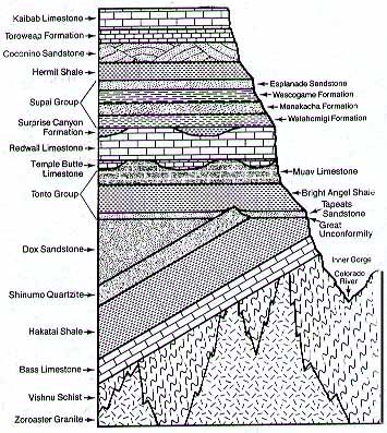
There is also a 'layer" called the Great Unconformity. What this is is a gap in the geologic record. There are several millions of years that did not leave any trace, so the rocks below on either side of it show vastly differing ages and spans. (And you think someone tearing out the last page of a story is frustrating? Imaging the geologists trying to unravel THAT mess!!!)
There are a lot of really cool horizontal layers that are pretty clear, even in the picture that I posted. You can pick out which layer something is by examining this picture and seeing pretty well where they are. Then, as the mule (or you) move down the trail, there are a series of tilted layers: this is a sign of major action inside the earth - plate tectonic actions such as subduction, that sort of thing. Whole areas of a location were raised on an angle, hence the change in direction toward the bottom of the picture.
The very bottom section shows no real pattern. The rock is big and bulky and, to be honest, very, very, VERY ancient. It's called Basement Rock sometimes. The big bruisers are there, the schists and the granites, and the age, as determined by Uranium or Potassium Argon dating is somewhere between 1.68 and 1.84 billion (yup, billion) years. . It's by travelling down through the canyon that one is able to see these ancient rocks and to somehow get a sense of the lapse of time between their foundations and now.
The Kaibab (remember that cute little squirrel?) Formation is about 270 million years ago and is at the rim of the canyon.
These are the ROCKS, not the Canyon itself.
The Canyon itself is something like 5 million years old. That's not exactly chump change, but compared to the rocks in and under it, we're not even talking the blink of an eye. Although there are varying theories, the oldest one - that the river did all of the carving on its own - is being modified to include the land uplifting around it, helping the river to do its thing, you might say. And, 5 million years ago when this all started, the river was much different than it is today...
I just wanted to show you this stuff because, to me, it's fascinating and you're either turned to another page, or you're captive (laughs a Simon LeGree laugh).
Of Mules:
Okay, I'll admit it, when I started to write about the Mule Trip down the canyon, I just sorta figured I'd describe it and that Mules were a little like Volkswagens, dependable, nothing to wild or sporty. And THEN I went looking for more information and was bowled over by what I started to learn. Soooo - tying this all in neatly with the Canyon, here is some fun stuff about mules:
Mules are the result of breeding a female horse with a male donkey. The animal that results is a hybrid and we call it a mule. ANY female horse of any breed may be cross bred. There are male donkeys of all sizes, from quite small to the biggest, which are called "Jack" donkeys and are pretty impressive specimens in their own right:
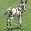
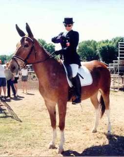
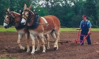
Here are some mules:


The little spotted fellow is a foal and a pretty young guy. His dam is either an appaloosa or an American spotted horse.
The lady in the second shot is preparing to enter the ring in dressage aboard her mule. Dressage for those who might not know, is an exacting discipline requiring the most explicit attention to form by both the horse and the rider or, in this case, the mule and the rider.
The third picture looks pretty much like your standard mule team. And it is, so long as one recognizes that the dam (mom) of each mule is a Belgian heavy draft horse. The dad is a Jack donkey.
In the last picture is a pair of prize winning carriage mules. Each of them stands 15.2 hands at the withers (the bump where the neck and the back meet), which is where all equines are measured. Each hand is 4 inches so each of the mules is 62 inches at the shoulder. (4x15= 60 + 2" = 62.)
Some of the characteristics of mules pretty much universally are as follows, and I'm comparing them to horses (one of my dearest loves):
A horse will eat until it founders: a mule stops when it's full
A horse will work no matter how abusive the situation, no matter how worn out the horse is, until it literally drops in its tracks: a mule will work until its life is in danger (either from hunger of exhaustion or abuse or any combination thereof) and then it stops. Which, if you get a quirky mule, may be JUUUUST a little sooner than a person might think (hence the term "stubborn as a mule"). In general, though, a mule has common sense.
A horse will run off a cliff (don't ask). A mule will stop and watch the horse run off a cliff. It will not follow it.
A horse can kick straight back or stamp an enemy under its front feet. A mule (watch out folks) can kick in any direction. So don't figure that, it you get on a mule's bad side, standing off to the side of the animal is going to help. It isn't.
But, overall, a mule has a steady and sane temperament. It's sure footed and, to my scant knowledge, no matter how irked by a screaming teenager or a sweaty businessman pretending he's John Wayne, there have been no accidents on the Bright Angel Trail Ride (a couple of pictures below):
An air shot of Grand Canyon village: the darker roofed large building with the arm that juts out toward the canyon is the El Tovar that we've already talked about. The mule corrals and stables are to the left and across the street.

These are a few of the mules that go down and up the trail. The trash bins in front can give you a general idea of their size.

No, we haven't reached the bottom of the canyon. This is the trail as it crosses the Tonto plateau (yup, a plateau in the Canyon - who'd a thunk it? See that edge there where it looks like the trail just goes "blip" and ends? That's the next leg of the journey!

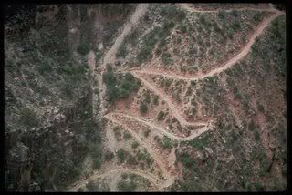
Here's the another trail from the air:

Mules have the right of way. If hikers are on the trail, they must step aside (against the wall edge).
My brother and his lovely wife Karen as well as another couple, the husband of which is an EMT, did the hike down from the North Rim (took 2 days) across the bottom of the canyon and then up the South Rim. They also trained for months to do it, and did it in the winter. It was still a run for the money. The walk is strenuous - if you feel adventurous, that's fine, but think it through. I think that the mule rides on the South Rim are booking a year out, but I could be wrong. Go to www.grandcanyon.com/gdnmule for information about booking rides from both the North and the South Rim(s).
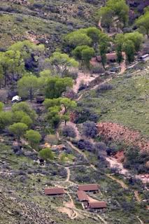
If you're riding down (or walking down, for that matter) there are a couple of places to stop: Indian Garden: this is the grand canyon version of that most important of places on any road: the rest stop. Depending on the tour you're taking or the hike you're contemplating, this is either a lunch stop before going on or the lunch stop before going back. The shot is from the air.

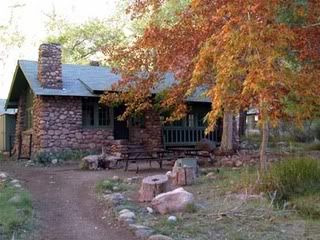
Should you be heading all the way down to the bottom of the Canyon by mule, you'll be staying overnight at the Phantom Ranch: this is just one of the cabins at the Ranch, which was originally built in 1922. The cabins are wood and stone from the canyon. This was originally a playground for the rich and famous who could afford to make the trip (a) to the Canyon itself and (b) to the bottom of the Canyon when they got to it. There is also a campground nearby.

At the bottom of the canyon, besides tremendous geology, there are the Havasu Falls:

See the rim of the Canyon WAAAAAY up there? Uh huh, that's a loooong way!
The Supai Nation also has its village in the bottom of the Canyon: I do not know the protocol for visiting the village. These are peoples' homes. If you are interested, I would suggest contacting someone at the Canyon via email. I'm sure that any questions that you might have can be answered.

There are other trails to be followed. There is a mule train that goes from the North Rim to the bottom of the Canyon and there are several other hiking trails of varying strenuousness. (Folks, remember, the Rim of the Canyon is over 7,000 feet above sea level on the South. Hiking even a gentle trail at that altitude can be difficult).
And this closes (you're cheering, I know) my tremendously long entries about the Grand Canyon. To say the least, I've only scratched at the surface. There are tons of images out there, humongous mountains of data, and, of course, the Canyon itself. I hope you've enjoyed! I've had a great time doing this!
Next? Heh..Gennessee Country Museum in Mumford New York (I needed a breather).
Have a great whatever!!!
There is also a 'layer" called the Great Unconformity. What this is is a gap in the geologic record. There are several millions of years that did not leave any trace, so the rocks below on either side of it show vastly differing ages and spans. (And you think someone tearing out the last page of a story is frustrating? Imaging the geologists trying to unravel THAT mess!!!)
There are a lot of really cool horizontal layers that are pretty clear, even in the picture that I posted. You can pick out which layer something is by examining this picture and seeing pretty well where they are. Then, as the mule (or you) move down the trail, there are a series of tilted layers: this is a sign of major action inside the earth - plate tectonic actions such as subduction, that sort of thing. Whole areas of a location were raised on an angle, hence the change in direction toward the bottom of the picture.
The very bottom section shows no real pattern. The rock is big and bulky and, to be honest, very, very, VERY ancient. It's called Basement Rock sometimes. The big bruisers are there, the schists and the granites, and the age, as determined by Uranium or Potassium Argon dating is somewhere between 1.68 and 1.84 billion (yup, billion) years. . It's by travelling down through the canyon that one is able to see these ancient rocks and to somehow get a sense of the lapse of time between their foundations and now.
The Kaibab (remember that cute little squirrel?) Formation is about 270 million years ago and is at the rim of the canyon.
These are the ROCKS, not the Canyon itself.
The Canyon itself is something like 5 million years old. That's not exactly chump change, but compared to the rocks in and under it, we're not even talking the blink of an eye. Although there are varying theories, the oldest one - that the river did all of the carving on its own - is being modified to include the land uplifting around it, helping the river to do its thing, you might say. And, 5 million years ago when this all started, the river was much different than it is today...
I just wanted to show you this stuff because, to me, it's fascinating and you're either turned to another page, or you're captive (laughs a Simon LeGree laugh).
Of Mules:
Okay, I'll admit it, when I started to write about the Mule Trip down the canyon, I just sorta figured I'd describe it and that Mules were a little like Volkswagens, dependable, nothing to wild or sporty. And THEN I went looking for more information and was bowled over by what I started to learn. Soooo - tying this all in neatly with the Canyon, here is some fun stuff about mules:
Mules are the result of breeding a female horse with a male donkey. The animal that results is a hybrid and we call it a mule. ANY female horse of any breed may be cross bred. There are male donkeys of all sizes, from quite small to the biggest, which are called "Jack" donkeys and are pretty impressive specimens in their own right:
Here are some mules:

The little spotted fellow is a foal and a pretty young guy. His dam is either an appaloosa or an American spotted horse.
The lady in the second shot is preparing to enter the ring in dressage aboard her mule. Dressage for those who might not know, is an exacting discipline requiring the most explicit attention to form by both the horse and the rider or, in this case, the mule and the rider.
The third picture looks pretty much like your standard mule team. And it is, so long as one recognizes that the dam (mom) of each mule is a Belgian heavy draft horse. The dad is a Jack donkey.
In the last picture is a pair of prize winning carriage mules. Each of them stands 15.2 hands at the withers (the bump where the neck and the back meet), which is where all equines are measured. Each hand is 4 inches so each of the mules is 62 inches at the shoulder. (4x15= 60 + 2" = 62.)
Some of the characteristics of mules pretty much universally are as follows, and I'm comparing them to horses (one of my dearest loves):
A horse will eat until it founders: a mule stops when it's full
A horse will work no matter how abusive the situation, no matter how worn out the horse is, until it literally drops in its tracks: a mule will work until its life is in danger (either from hunger of exhaustion or abuse or any combination thereof) and then it stops. Which, if you get a quirky mule, may be JUUUUST a little sooner than a person might think (hence the term "stubborn as a mule"). In general, though, a mule has common sense.
A horse will run off a cliff (don't ask). A mule will stop and watch the horse run off a cliff. It will not follow it.
A horse can kick straight back or stamp an enemy under its front feet. A mule (watch out folks) can kick in any direction. So don't figure that, it you get on a mule's bad side, standing off to the side of the animal is going to help. It isn't.
But, overall, a mule has a steady and sane temperament. It's sure footed and, to my scant knowledge, no matter how irked by a screaming teenager or a sweaty businessman pretending he's John Wayne, there have been no accidents on the Bright Angel Trail Ride (a couple of pictures below):
An air shot of Grand Canyon village: the darker roofed large building with the arm that juts out toward the canyon is the El Tovar that we've already talked about. The mule corrals and stables are to the left and across the street.

These are a few of the mules that go down and up the trail. The trash bins in front can give you a general idea of their size.

No, we haven't reached the bottom of the canyon. This is the trail as it crosses the Tonto plateau (yup, a plateau in the Canyon - who'd a thunk it? See that edge there where it looks like the trail just goes "blip" and ends? That's the next leg of the journey!

Here's the another trail from the air:
Mules have the right of way. If hikers are on the trail, they must step aside (against the wall edge).
My brother and his lovely wife Karen as well as another couple, the husband of which is an EMT, did the hike down from the North Rim (took 2 days) across the bottom of the canyon and then up the South Rim. They also trained for months to do it, and did it in the winter. It was still a run for the money. The walk is strenuous - if you feel adventurous, that's fine, but think it through. I think that the mule rides on the South Rim are booking a year out, but I could be wrong. Go to www.grandcanyon.com/gdnmule for information about booking rides from both the North and the South Rim(s).
If you're riding down (or walking down, for that matter) there are a couple of places to stop: Indian Garden: this is the grand canyon version of that most important of places on any road: the rest stop. Depending on the tour you're taking or the hike you're contemplating, this is either a lunch stop before going on or the lunch stop before going back. The shot is from the air.
Should you be heading all the way down to the bottom of the Canyon by mule, you'll be staying overnight at the Phantom Ranch: this is just one of the cabins at the Ranch, which was originally built in 1922. The cabins are wood and stone from the canyon. This was originally a playground for the rich and famous who could afford to make the trip (a) to the Canyon itself and (b) to the bottom of the Canyon when they got to it. There is also a campground nearby.
At the bottom of the canyon, besides tremendous geology, there are the Havasu Falls:

See the rim of the Canyon WAAAAAY up there? Uh huh, that's a loooong way!
The Supai Nation also has its village in the bottom of the Canyon: I do not know the protocol for visiting the village. These are peoples' homes. If you are interested, I would suggest contacting someone at the Canyon via email. I'm sure that any questions that you might have can be answered.

There are other trails to be followed. There is a mule train that goes from the North Rim to the bottom of the Canyon and there are several other hiking trails of varying strenuousness. (Folks, remember, the Rim of the Canyon is over 7,000 feet above sea level on the South. Hiking even a gentle trail at that altitude can be difficult).
And this closes (you're cheering, I know) my tremendously long entries about the Grand Canyon. To say the least, I've only scratched at the surface. There are tons of images out there, humongous mountains of data, and, of course, the Canyon itself. I hope you've enjoyed! I've had a great time doing this!
Next? Heh..Gennessee Country Museum in Mumford New York (I needed a breather).
Have a great whatever!!!
My Trip West - Part 16
And here I am AGAIN!
Back to the Canyon (I know, I know, you're tired of it) for a little tour and tangent.
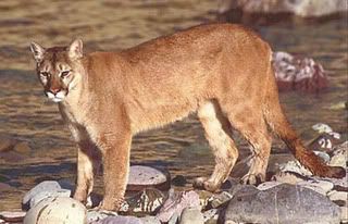
But first, on the last post, I accidentally deep sixed a picture of an adult mountain lion (cougar, painter, panther, puma). Here is it, just for the record:

They are not considered a big cat (although, since they're fourth in line after tigers, lions and jaguars, I don't understand the logic. But that would be me). However, they are far from small: the average length is 60-95 inches (including the tail). A tiger's average as the biggest big cat is 13 feet from snout to tail. Just to give a range of sizes. And at 5 feet to almost 8 feet, a mountain lion is a pretty intimidating animal to meet along a pathway (most of the time, since they're completely shy, you won't meet 'em. They don't like people at all. Can't imagine why!)
There have never been any cases around the Grand Canyon of a human being attacked by a mountain lion. They have a full time job keeping the Mule Deer and Elk under control (both are far more a cougar's cup of lap song).
Now, on we go to geology! And you've come to read this because you wanted to know all about the geology of the Grand Canyon, right?
Seriously, I think the thing that captivated me the most about Joseph Wood Krutch's book (Grand Canyon: Today and All Its Yesterdays) was the concept that, while either looking down from a looking down point or walking down (are you CRAZY?) or riding down into the canyon aboard a mule (more about those to follow), an individual is literally looking back at the geologic beginnings of our planet. Mr. Krutch's details have been corrected over the decades by more accurate dating methods, but the amazement only increases with those more accurate measurements.
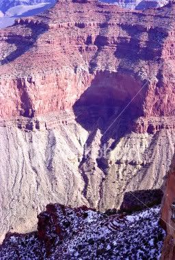
Here's a pretty pic looking at the canyon (now, where did I stick that?) We're not looking all the way down to the bottom, but you get the general idea: there are a lot of horizontal layers (it's not a torte, but it reminds me of one...chocolate...ooops, I got distracted). Some of the layers are thick, some stick out as appearing more a solid rock layer than the layers around them, but there are a herd of layers or striae just waiting for us to look at.

I just noticed! There's snow in the picture! Cool!!!
Here is a less pretty picture, but it tells us a lot about the layers:
Much of the layering is sedimentary rock (sandstone, limestone (remember Kartchner Caverns?) are both sedimentary.
Some of the rock is metamorphic : they started out as one rock and were transformed by one or more methods, into another rock. So sandstone, for example, if subjected to heat and pressure, may metamorphose into quartzite. shale may transform into slate or schist, among other things (no giggling in the back - the word is shhhist). I'm saying "may" because it isn't a given that these changes will occur.
Igneous rocks are associated with volcanoes, but they can also be the product of a large "blob" of molten rock being forced to the surface, but not erupting
Back to the Canyon (I know, I know, you're tired of it) for a little tour and tangent.
But first, on the last post, I accidentally deep sixed a picture of an adult mountain lion (cougar, painter, panther, puma). Here is it, just for the record:
They are not considered a big cat (although, since they're fourth in line after tigers, lions and jaguars, I don't understand the logic. But that would be me). However, they are far from small: the average length is 60-95 inches (including the tail). A tiger's average as the biggest big cat is 13 feet from snout to tail. Just to give a range of sizes. And at 5 feet to almost 8 feet, a mountain lion is a pretty intimidating animal to meet along a pathway (most of the time, since they're completely shy, you won't meet 'em. They don't like people at all. Can't imagine why!)
There have never been any cases around the Grand Canyon of a human being attacked by a mountain lion. They have a full time job keeping the Mule Deer and Elk under control (both are far more a cougar's cup of lap song).
Now, on we go to geology! And you've come to read this because you wanted to know all about the geology of the Grand Canyon, right?
Seriously, I think the thing that captivated me the most about Joseph Wood Krutch's book (Grand Canyon: Today and All Its Yesterdays) was the concept that, while either looking down from a looking down point or walking down (are you CRAZY?) or riding down into the canyon aboard a mule (more about those to follow), an individual is literally looking back at the geologic beginnings of our planet. Mr. Krutch's details have been corrected over the decades by more accurate dating methods, but the amazement only increases with those more accurate measurements.
Here's a pretty pic looking at the canyon (now, where did I stick that?) We're not looking all the way down to the bottom, but you get the general idea: there are a lot of horizontal layers (it's not a torte, but it reminds me of one...chocolate...ooops, I got distracted). Some of the layers are thick, some stick out as appearing more a solid rock layer than the layers around them, but there are a herd of layers or striae just waiting for us to look at.
I just noticed! There's snow in the picture! Cool!!!
Here is a less pretty picture, but it tells us a lot about the layers:
Much of the layering is sedimentary rock (sandstone, limestone (remember Kartchner Caverns?) are both sedimentary.
Some of the rock is metamorphic : they started out as one rock and were transformed by one or more methods, into another rock. So sandstone, for example, if subjected to heat and pressure, may metamorphose into quartzite. shale may transform into slate or schist, among other things (no giggling in the back - the word is shhhist). I'm saying "may" because it isn't a given that these changes will occur.
Igneous rocks are associated with volcanoes, but they can also be the product of a large "blob" of molten rock being forced to the surface, but not erupting
Saturday, March 26, 2011
My Trip West - Part 15
Here we are again and it's Part II.
Once again, thank you to the folks who's posted images out on the web or photobucket, because without them, I wouldn't have piccies to show y'all. Yes, I'm TERRIBLE at pictures...It's like baking cookies. In life there are bakers and people who appreciate good baking but can't do it for the life of them. I fall into the latter category (with the exception of making bread. THAT I can do). Same thing with pictures...
Yesterday (or the day before...no, yesterday) we did some looking around and seeing different things at the Canyon. But there weren't a lot of the grand photos that everyone associates (and has seen) of the big hole. Today, I'll try for something a little more scenic, I promise.
Let's see...Heh..for the life of me, I can't seem to get away from the surprise people display when i say that it snows in Arizona. And it definitely snows in the canyon. Here are a couple of snowy shots. The first one is a plow trying to clear up a driveway on the North Rim (the one that most people don't visit because...we..just because, I guess). Fortunately, he didn't plow up any Kaibab squirrels while he was scraping the lot. The second one is a snow trail on the South Rim. Unlike the North Rim, the South Rim is open year round.


And, in a typical move on my part, I'm going to put in something I should have put in yesterday. It's a map of the park, including Grand Canyon Village. Yup, there is a small village off the South Rim. It houses employees, of course, but there are also rental cabins, and it's the terminus for a railroad spur.

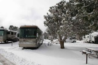
And another snow picture, this time snow in the main parking lot in the village:
Note the nice snow. This will stay for a day anyway because the temps are cool enough to support it. But I can guarantee that within an hour of the end of the snowfall, the sky will be so blue the color will look fake. (Fun factoid: The human eye sees more tones of blue than any other color. Counted cross stitchers learn the strangest things!)

The map gives you an idea of the size of the park. And you can see the Village (it has its own post office. Cool place to send post cards to great aunt Charlene from...especially if she thinks you're in London...)
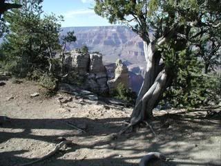
The trees, by the way, are wondrous as well. The Pinon Pine(I don't have an "n-ya ,an n with a tilde over it, that I can get to, but the pronunciation is Pin-yon) is my favorite on the South Rim. Here's a picture of a tree that is a great deal older than its height would suggest:

Actually, I think I took a picture of a pinon that wasn't too horrible once upon a time. Their trunks are gnarled and they cling to the shallow soil and bedrock with root fingers that are as tough as can be: ekeing a life out of the soil at the canyon isn't easy for anything.
One of my other favorite birds, the raven, flies in the canyon. I've seen the raven confused with its little cousin, the American Crow, but they are distinct as day and night. The raven is a large bird - their wingspan is anything from 47-52". The stories of its intelligence and socialization skills, not to mention the legends surrounding Raven, are many and varied. Here are a couple of pictures of Raven - one on the ground and one up soaring (gotta love those thermals!!!)


The raven has a thicker bill, all black, as well as a "ruff" of long neck feathers. A crow (not an insignificant fellow in his own right) has about a 30" wingspan, is much smaller (although still a significantly large bird) and has a higher voice without the hoarseness of a raven. They're an altogether handsome family of birds, very intelligent and opportunistic, hence their omnivorous diets.
The first time I saw a raven, it was flying several thousand feet below me in the canyon. I couldn't begin to identify it, although my instincts were to put it in with pterodactyls!!!! Large! But much nicer looking that pterodactyls. Love the corvids, I do!
There are also, thank goodness, a small and very secretive population of mountain lions near the park. If ti weren't for those birds and coyotes, the populations of deer would overrun the place. There is an activity at the park right now involved in tagging and tracking mountain lion cubs to examine the population. There have not been any incidents between humans and the big cats (they're the 4th largest in the world after Lions, Tigers, and Jaguars) mostly because mountain lions are loners and prefer to keep away from people. Here's the "awwww" picture for tonight. It's a little fella who's been ear tagged:

Just look at those feet! He'll lose the blue in his eyes as he grows, until he looks like this:
There are all sorts of other animals near or in the park, of course. Javelinas, ground squirrels (not prairie dogs, those are different), homo sapiens (you thought maybe we were plants?), butterflies, two types of scorpions (which don't hunt people. If you stay out of their way, they'll leave you alone.), one species of rattlesnake (on the rim) which gives a warning just as all rattlers do. When you hear the sound, stand still and try to spot it. Then stand still some more until it moves off. They don't hunt humans, either. There is also the infamous black widow spider (nasty thing she is, too), but, again, the only danger comes when people forget to (a) shake out their shoes, socks, pants, and other clothing before they put them on, (b) forget to shake out bedding before settling in (c) hear a warning from a rattler and then decide to chase it or (d) invite a scorpion in for dinner. The bark scorpion is about 2" long and has the more painful venom of the two. All scorpion venom stings, some a great deal more than others. Shake things out, examine things before you reach into cupboards or backpacks.. You should be fine.
All righty, then, let's take a look at some pictures:
Remember that the best times of day are just after a rain or a snow, sunrise and sunset. The middle of the day is when pictures are taken that may show the canyon as a panorama, but also show it as almost determinedly two dimensional. Try to avoid pictures like that (it's probably too warm for you to be out snapping shots anyway).
Getting around the Canyon -South Rim
Although, in the old days (like the 80s), it was possible to drive cars to a number of the lookouts, the amount of traffic has increased to the point that the lookouts are in danger. So, to alleviate the stress, shuttle bus transport takes people from point to point. It's pretty cool, really. You're not locked into a ride on one bus. You get on, ride to where you want to stop, stop, do what you want (including walking to the next lookout if you feel you can) and then grab another bus when it or its next bus comes through. The West side of the South Rim (going out to Hermit's Point) has been accessible by buses only for years. Leave the driving to others. Remember to take your water and wear good walking shoes, and you're free to enjoy the park without having to fight the traffic. MOST cool, in my book.
Here we go:
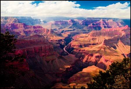
This is one view from Yavapai (YAH-vah-pie) Point. See what some clouds will do for perspective. The width of the varies from 4 miles to over 20, and I'm guessing that we're somewhere in the upper reaches of its width. I know it's not easy to fathom, and that I'm being a little cavalier about 20 miles or 24 (yup), so, when you see it live, be ready.

The neat thing in this picture (besides all the rocks and stuff) is that you can actually see the Colorado River down (way down) below. It's kind of squiggly with a wide spot of pale pink, which is water. For a long time, the Colorado River was kept under control by the Hoover Dam, which created Lake Mead when it was completed in the 1930s. However, in recent years, the necessity of flooding the Canyon, as the river did regularly before it was tamed, has been re-learned. It's sort of like clearing the dust and cobwebs out of gutters. So, every now and then, when the situation both water wise (and water rights are one of the most hotly contested issues in the southwest and the west in general) and ecology wise are right, the river is flooded. Just wanted to throw that in. (No, no one's allowed to white water raft when that happens. Sorry, you wild and crazy river rafters, you!!!)

This is the river (shiny little bit down there) from Yuma Point. We're seeing the light at or near the sunniest part of the day.

Lest you think I'm giving the North Rim short shrift, here's a shot from the North Rim. It's gorgeous (but I am very fond of pinks and purples)

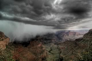
This is a thunderstorm over the canyon. If you squint and look closely toward the middle left edge, you'll see a lightning strike. And if you look off toward the right edge of the picture, you'll see that the storm either hasn't hit there yet or has already moved out, leaving blue skies.
One of the most wonderful things about the canyon is the ability to see the weather moving across it.

This is a view to the East from Maricopa Point, South Rim (yeah, another gorgeous view...sigh...)

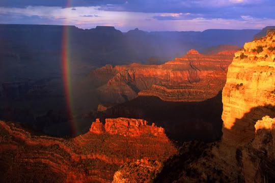
I forgot something! We had a rainstorm a picture or so up, and, of course, we need a rainbow! The colors are not enhanced. I've seen this brilliance, usually it happens because there are clouds near where the sun in and the light shines through a gap, focusing intensity in one area. Same thing as at sunrise (and that you have to see) ...

This is another shot from the North Rim. I haven't been there, so I'm looking at these as intently as you are. I think I 'm going to have to head out that-a-way!

I am realizing that I haven't told anything about the mules or the Bright Angel Trail and I think I could find, oh, maybe something about several million years worth of rocks that tell a geologic tale without making you too bored. SO, I'm going to close for tonight and thing about other things to describe tomorrow!!!!
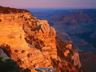
This is sunrise from Mather Point on the South Rim - if you look toward the far horizon, you can see that day is only now beginning to chase away the pre-dawn hours.

I bid you good night, gentlefolk, all! Until the next installment!
Once again, thank you to the folks who's posted images out on the web or photobucket, because without them, I wouldn't have piccies to show y'all. Yes, I'm TERRIBLE at pictures...It's like baking cookies. In life there are bakers and people who appreciate good baking but can't do it for the life of them. I fall into the latter category (with the exception of making bread. THAT I can do). Same thing with pictures...
Yesterday (or the day before...no, yesterday) we did some looking around and seeing different things at the Canyon. But there weren't a lot of the grand photos that everyone associates (and has seen) of the big hole. Today, I'll try for something a little more scenic, I promise.
Let's see...Heh..for the life of me, I can't seem to get away from the surprise people display when i say that it snows in Arizona. And it definitely snows in the canyon. Here are a couple of snowy shots. The first one is a plow trying to clear up a driveway on the North Rim (the one that most people don't visit because...we..just because, I guess). Fortunately, he didn't plow up any Kaibab squirrels while he was scraping the lot. The second one is a snow trail on the South Rim. Unlike the North Rim, the South Rim is open year round.

And, in a typical move on my part, I'm going to put in something I should have put in yesterday. It's a map of the park, including Grand Canyon Village. Yup, there is a small village off the South Rim. It houses employees, of course, but there are also rental cabins, and it's the terminus for a railroad spur.

And another snow picture, this time snow in the main parking lot in the village:
Note the nice snow. This will stay for a day anyway because the temps are cool enough to support it. But I can guarantee that within an hour of the end of the snowfall, the sky will be so blue the color will look fake. (Fun factoid: The human eye sees more tones of blue than any other color. Counted cross stitchers learn the strangest things!)
The map gives you an idea of the size of the park. And you can see the Village (it has its own post office. Cool place to send post cards to great aunt Charlene from...especially if she thinks you're in London...)
The trees, by the way, are wondrous as well. The Pinon Pine(I don't have an "n-ya ,an n with a tilde over it, that I can get to, but the pronunciation is Pin-yon) is my favorite on the South Rim. Here's a picture of a tree that is a great deal older than its height would suggest:
Actually, I think I took a picture of a pinon that wasn't too horrible once upon a time. Their trunks are gnarled and they cling to the shallow soil and bedrock with root fingers that are as tough as can be: ekeing a life out of the soil at the canyon isn't easy for anything.
One of my other favorite birds, the raven, flies in the canyon. I've seen the raven confused with its little cousin, the American Crow, but they are distinct as day and night. The raven is a large bird - their wingspan is anything from 47-52". The stories of its intelligence and socialization skills, not to mention the legends surrounding Raven, are many and varied. Here are a couple of pictures of Raven - one on the ground and one up soaring (gotta love those thermals!!!)


The raven has a thicker bill, all black, as well as a "ruff" of long neck feathers. A crow (not an insignificant fellow in his own right) has about a 30" wingspan, is much smaller (although still a significantly large bird) and has a higher voice without the hoarseness of a raven. They're an altogether handsome family of birds, very intelligent and opportunistic, hence their omnivorous diets.
The first time I saw a raven, it was flying several thousand feet below me in the canyon. I couldn't begin to identify it, although my instincts were to put it in with pterodactyls!!!! Large! But much nicer looking that pterodactyls. Love the corvids, I do!
There are also, thank goodness, a small and very secretive population of mountain lions near the park. If ti weren't for those birds and coyotes, the populations of deer would overrun the place. There is an activity at the park right now involved in tagging and tracking mountain lion cubs to examine the population. There have not been any incidents between humans and the big cats (they're the 4th largest in the world after Lions, Tigers, and Jaguars) mostly because mountain lions are loners and prefer to keep away from people. Here's the "awwww" picture for tonight. It's a little fella who's been ear tagged:

Just look at those feet! He'll lose the blue in his eyes as he grows, until he looks like this:
There are all sorts of other animals near or in the park, of course. Javelinas, ground squirrels (not prairie dogs, those are different), homo sapiens (you thought maybe we were plants?), butterflies, two types of scorpions (which don't hunt people. If you stay out of their way, they'll leave you alone.), one species of rattlesnake (on the rim) which gives a warning just as all rattlers do. When you hear the sound, stand still and try to spot it. Then stand still some more until it moves off. They don't hunt humans, either. There is also the infamous black widow spider (nasty thing she is, too), but, again, the only danger comes when people forget to (a) shake out their shoes, socks, pants, and other clothing before they put them on, (b) forget to shake out bedding before settling in (c) hear a warning from a rattler and then decide to chase it or (d) invite a scorpion in for dinner. The bark scorpion is about 2" long and has the more painful venom of the two. All scorpion venom stings, some a great deal more than others. Shake things out, examine things before you reach into cupboards or backpacks.. You should be fine.
All righty, then, let's take a look at some pictures:
Remember that the best times of day are just after a rain or a snow, sunrise and sunset. The middle of the day is when pictures are taken that may show the canyon as a panorama, but also show it as almost determinedly two dimensional. Try to avoid pictures like that (it's probably too warm for you to be out snapping shots anyway).
Getting around the Canyon -South Rim
Although, in the old days (like the 80s), it was possible to drive cars to a number of the lookouts, the amount of traffic has increased to the point that the lookouts are in danger. So, to alleviate the stress, shuttle bus transport takes people from point to point. It's pretty cool, really. You're not locked into a ride on one bus. You get on, ride to where you want to stop, stop, do what you want (including walking to the next lookout if you feel you can) and then grab another bus when it or its next bus comes through. The West side of the South Rim (going out to Hermit's Point) has been accessible by buses only for years. Leave the driving to others. Remember to take your water and wear good walking shoes, and you're free to enjoy the park without having to fight the traffic. MOST cool, in my book.
Here we go:
This is one view from Yavapai (YAH-vah-pie) Point. See what some clouds will do for perspective. The width of the varies from 4 miles to over 20, and I'm guessing that we're somewhere in the upper reaches of its width. I know it's not easy to fathom, and that I'm being a little cavalier about 20 miles or 24 (yup), so, when you see it live, be ready.

The neat thing in this picture (besides all the rocks and stuff) is that you can actually see the Colorado River down (way down) below. It's kind of squiggly with a wide spot of pale pink, which is water. For a long time, the Colorado River was kept under control by the Hoover Dam, which created Lake Mead when it was completed in the 1930s. However, in recent years, the necessity of flooding the Canyon, as the river did regularly before it was tamed, has been re-learned. It's sort of like clearing the dust and cobwebs out of gutters. So, every now and then, when the situation both water wise (and water rights are one of the most hotly contested issues in the southwest and the west in general) and ecology wise are right, the river is flooded. Just wanted to throw that in. (No, no one's allowed to white water raft when that happens. Sorry, you wild and crazy river rafters, you!!!)
This is the river (shiny little bit down there) from Yuma Point. We're seeing the light at or near the sunniest part of the day.

Lest you think I'm giving the North Rim short shrift, here's a shot from the North Rim. It's gorgeous (but I am very fond of pinks and purples)

This is a thunderstorm over the canyon. If you squint and look closely toward the middle left edge, you'll see a lightning strike. And if you look off toward the right edge of the picture, you'll see that the storm either hasn't hit there yet or has already moved out, leaving blue skies.
One of the most wonderful things about the canyon is the ability to see the weather moving across it.
This is a view to the East from Maricopa Point, South Rim (yeah, another gorgeous view...sigh...)

I forgot something! We had a rainstorm a picture or so up, and, of course, we need a rainbow! The colors are not enhanced. I've seen this brilliance, usually it happens because there are clouds near where the sun in and the light shines through a gap, focusing intensity in one area. Same thing as at sunrise (and that you have to see) ...
This is another shot from the North Rim. I haven't been there, so I'm looking at these as intently as you are. I think I 'm going to have to head out that-a-way!

I am realizing that I haven't told anything about the mules or the Bright Angel Trail and I think I could find, oh, maybe something about several million years worth of rocks that tell a geologic tale without making you too bored. SO, I'm going to close for tonight and thing about other things to describe tomorrow!!!!
This is sunrise from Mather Point on the South Rim - if you look toward the far horizon, you can see that day is only now beginning to chase away the pre-dawn hours.
I bid you good night, gentlefolk, all! Until the next installment!
My Trip West - Part 14
And it IS that, although "grand, magnificent, marvelous, wonder-full" and all those words just pale when a person walks to the rim and looks down. And down. And down. And down.
There are so many things to know about the canyon that just the bare bones would (and have) filled books. I'm going to stick to the barest of bare bones here.
The Canyon runs East and West through the Navajo Nation as well as several other native American nations. There are two "rims" that are spoken of. The South Rim is the most visited, the most photographed, and the most storied. The North Rim is less visited and, unlike the south rim, is closed from roughly mid October (precise date depends on the snowfall level) until May (ditto the precise date). To reach the North Rim from the South is a trip of over 200 miles.
The Canyon's Depth is an average of 6000 feet (that's DEEP) in the park, or over 1 mile. When someone looks at a topographic map of the canyon, it's important to remember that the topography is measured from sea level and that notations of 4000 feet, etc. are from sea level.
The South Rim's elevation (above sea level) is about 7000 feet. The North Rim's elevation is approximately 8000 feet above sea level.
Remember what I wrote about acclimating to high altitudes? All of that goes for both rims of the canyon. Be careful, especially on the North Rim. The heart you save will be yours! Water, water, rest, water, water, food...
I'm not going to go through the entire history of the discovery of the Canyon. Lord knows there are a million articles and books about it out there. John Wesley Powell and his intrepid adventures as the first man (and accompanying party members) to row through the Canyon is the stuff of legend. Indeed, it's possible to see one of the (really) tiny boats that they used to make the journey. It was the 19th century, after all, and the rafts used to run the rapids of the Colorado today had not been invented yet.
Theodore Roosevelt's love affair with the Grand Canyon is also well known (he was instrumental in declaring it a national park), and I think that the influence of the railroads, which served to open the canyon to tourism on a modest scale early on, are also fairly well known.
I am going to hit on (ooops) talk a little about (much better) a couple of interesting facts and things, and hope that you might enjoy that.
Of squirrels and geographic separation:
On the south rim of the canyon, you may, if you're lucky, see Albert's squirrels. They don't belong to someone named Albert, of course, but they are the grey members of a tufted eared family of squirrels. They're really good looking (and they know it) and the ones near human habitations in the canyon are fearless. Here's one:

Cheeky little fella, but very cute!
On the North Rim of the Canyon (and only on the North Rim of the Canyon) is another tufted squirrel. He's, to all intents, a tufted squirrel just like the little guy up above. But the Kaibab squirrel has developed a strikingly different appearance. Here's a pretty good picture of one. They're rare and not the least bit comfortable around humans.

Just goes to show what a few millennia of geographic isolation can do...and you didn't have to go to the Galapagos to see it!!!
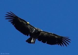
There is another wonder in the Canyon, a relatively new re-introduction to the avian food chain. That would be the California Condor. Again, there have been books and articles written for decades about the dedication and ferocious determination of not only the scientists involved but also a great many average folk in terms of the preservation of the California Condor. From only approximately 25 living in the wild (that there were some in zoos was critical in terms of the survival of the species. If the 25 in the wild had been the only genetic pool to pull from, there would have been little to no chance of bringing this magnificent bird back). Today the California Condor has been reintroduced to a remote section of the Grand Canyon. There are now an estimated 160 California Condors in the wild. Still a tiny number, of course, but they are (at least in terms of the Canyon) in a spot that is both remote and almost impossible to get to (like much of the canyon).
Someday, I hope to be able to see one soaring below me through the canyon. But, until then, I am glad to know they're there. Here's a picture:

The average wing span (tip to tip) is 9 feet or 2.74 meters. That is a large bird, to say the least. They're soarers once they're airborne, and the updrafts and cross currents in the canyon are perfect for their purposes.
Mary Colter: architect
What's an architect doing in a discussion of the Grand Canyon, you may ask.
If the architect is Mary Colter, it's because she designed and built (as an employee of the Harvey Company, of Harvey House fame) locations on the South Rim that are still in use today, nearly a century later. She was born in 1869 and in 1886, in a move that was rare for a female at that time, attended the California School of Design. In 1901 she was hired by the Harvey Company and, in 1910, after a stint with them as a decorator, became a full time architect for the company.
She designed and built the Watchtower (picture below. It's the one that looks like a tower...sorry, I couldn't help it), Hermit's Rest, Hopi House, and Lookout Studio as well as decorating El Tovar (I have a problem putting "The" in front of "El" which is "the" in Spanish...sigh...)
The Watchtower is just that - the really neat thing in addition to the large spiral staircase with observation windows built into the walls and all of the wooden floors as well as the view from the top - is that the watchtower looks as if it's just built of stone, but Ms. Colter decided not to risk anything falling over time and put a steel superstructure inside the building. Pretty cool for the early 1900s!
Along with her work on the buildings for the canyon, she designed numerous other structures in the Southwest. It's safe to say that Mary Colter's view of the buildings of the southwest, filtered through her own observations and architectural training, stamped an image of what buildings in the canyon SHOULD be.
Pictures below:


The second is part of the interior of the Watchtower. Neat, huh?

This is the arched way that leads to Hermit's Rest.
I could keep on showing pictures of buildings for awhile, and I do want to show one more. This is El Tovar from the outside. El Tovar was opened in 1905, when reaching the canyon was a huge and lengthy adventure. It was constructed, quite literally, within a few tens of yards from the rim of the Canyon. I've been there several times to eat (it's expensive to stay at El Tovar, but one can still enjoy the ambience while dining) and the views both of the interior of the hotel and of the Canyon are marvellous:
The Exterior. Well, part of the Exterior. This is the main door with its hanging sign. The hotel expands quite a long way to each side.

The main dining room of the hotel: this shot is looking toward the inside of the dining room. (Thank goodness for photographers who know how to do things like exposures on the insides of things!!! Bless 'em all!). To my mind, having eaten here, the linens, the impeccable service (many of the servers are college students from all over the US and the rest of the world. There's something about this grand lady (and not Old Lady - we're talking about a building on the edge of a canyon with rocks older than old itself. El Tovar is a demure young thing by comparison) that makes people, even the most casually dressed customers, sit up and behave well. Can't explain it, don't want to. I think it's pretty cool. It tamed me (for a little while.)

I haven't shown much of the Canyon itself, so I'm going to close this section (yup, there's more than one) with a view some wonderful person took from the balcony at El Tovar as sunset did its daily and ever changing paint job:

Part II ahead! I need to take a rest and stretch my legs!!!!
There are so many things to know about the canyon that just the bare bones would (and have) filled books. I'm going to stick to the barest of bare bones here.
The Canyon runs East and West through the Navajo Nation as well as several other native American nations. There are two "rims" that are spoken of. The South Rim is the most visited, the most photographed, and the most storied. The North Rim is less visited and, unlike the south rim, is closed from roughly mid October (precise date depends on the snowfall level) until May (ditto the precise date). To reach the North Rim from the South is a trip of over 200 miles.
The Canyon's Depth is an average of 6000 feet (that's DEEP) in the park, or over 1 mile. When someone looks at a topographic map of the canyon, it's important to remember that the topography is measured from sea level and that notations of 4000 feet, etc. are from sea level.
The South Rim's elevation (above sea level) is about 7000 feet. The North Rim's elevation is approximately 8000 feet above sea level.
Remember what I wrote about acclimating to high altitudes? All of that goes for both rims of the canyon. Be careful, especially on the North Rim. The heart you save will be yours! Water, water, rest, water, water, food...
I'm not going to go through the entire history of the discovery of the Canyon. Lord knows there are a million articles and books about it out there. John Wesley Powell and his intrepid adventures as the first man (and accompanying party members) to row through the Canyon is the stuff of legend. Indeed, it's possible to see one of the (really) tiny boats that they used to make the journey. It was the 19th century, after all, and the rafts used to run the rapids of the Colorado today had not been invented yet.
Theodore Roosevelt's love affair with the Grand Canyon is also well known (he was instrumental in declaring it a national park), and I think that the influence of the railroads, which served to open the canyon to tourism on a modest scale early on, are also fairly well known.
I am going to hit on (ooops) talk a little about (much better) a couple of interesting facts and things, and hope that you might enjoy that.
Of squirrels and geographic separation:
On the south rim of the canyon, you may, if you're lucky, see Albert's squirrels. They don't belong to someone named Albert, of course, but they are the grey members of a tufted eared family of squirrels. They're really good looking (and they know it) and the ones near human habitations in the canyon are fearless. Here's one:

Cheeky little fella, but very cute!
On the North Rim of the Canyon (and only on the North Rim of the Canyon) is another tufted squirrel. He's, to all intents, a tufted squirrel just like the little guy up above. But the Kaibab squirrel has developed a strikingly different appearance. Here's a pretty good picture of one. They're rare and not the least bit comfortable around humans.

Just goes to show what a few millennia of geographic isolation can do...and you didn't have to go to the Galapagos to see it!!!
There is another wonder in the Canyon, a relatively new re-introduction to the avian food chain. That would be the California Condor. Again, there have been books and articles written for decades about the dedication and ferocious determination of not only the scientists involved but also a great many average folk in terms of the preservation of the California Condor. From only approximately 25 living in the wild (that there were some in zoos was critical in terms of the survival of the species. If the 25 in the wild had been the only genetic pool to pull from, there would have been little to no chance of bringing this magnificent bird back). Today the California Condor has been reintroduced to a remote section of the Grand Canyon. There are now an estimated 160 California Condors in the wild. Still a tiny number, of course, but they are (at least in terms of the Canyon) in a spot that is both remote and almost impossible to get to (like much of the canyon).
Someday, I hope to be able to see one soaring below me through the canyon. But, until then, I am glad to know they're there. Here's a picture:
The average wing span (tip to tip) is 9 feet or 2.74 meters. That is a large bird, to say the least. They're soarers once they're airborne, and the updrafts and cross currents in the canyon are perfect for their purposes.
Mary Colter: architect
What's an architect doing in a discussion of the Grand Canyon, you may ask.
If the architect is Mary Colter, it's because she designed and built (as an employee of the Harvey Company, of Harvey House fame) locations on the South Rim that are still in use today, nearly a century later. She was born in 1869 and in 1886, in a move that was rare for a female at that time, attended the California School of Design. In 1901 she was hired by the Harvey Company and, in 1910, after a stint with them as a decorator, became a full time architect for the company.
She designed and built the Watchtower (picture below. It's the one that looks like a tower...sorry, I couldn't help it), Hermit's Rest, Hopi House, and Lookout Studio as well as decorating El Tovar (I have a problem putting "The" in front of "El" which is "the" in Spanish...sigh...)
The Watchtower is just that - the really neat thing in addition to the large spiral staircase with observation windows built into the walls and all of the wooden floors as well as the view from the top - is that the watchtower looks as if it's just built of stone, but Ms. Colter decided not to risk anything falling over time and put a steel superstructure inside the building. Pretty cool for the early 1900s!
Along with her work on the buildings for the canyon, she designed numerous other structures in the Southwest. It's safe to say that Mary Colter's view of the buildings of the southwest, filtered through her own observations and architectural training, stamped an image of what buildings in the canyon SHOULD be.
Pictures below:


The second is part of the interior of the Watchtower. Neat, huh?

This is the arched way that leads to Hermit's Rest.
I could keep on showing pictures of buildings for awhile, and I do want to show one more. This is El Tovar from the outside. El Tovar was opened in 1905, when reaching the canyon was a huge and lengthy adventure. It was constructed, quite literally, within a few tens of yards from the rim of the Canyon. I've been there several times to eat (it's expensive to stay at El Tovar, but one can still enjoy the ambience while dining) and the views both of the interior of the hotel and of the Canyon are marvellous:
The Exterior. Well, part of the Exterior. This is the main door with its hanging sign. The hotel expands quite a long way to each side.

The main dining room of the hotel: this shot is looking toward the inside of the dining room. (Thank goodness for photographers who know how to do things like exposures on the insides of things!!! Bless 'em all!). To my mind, having eaten here, the linens, the impeccable service (many of the servers are college students from all over the US and the rest of the world. There's something about this grand lady (and not Old Lady - we're talking about a building on the edge of a canyon with rocks older than old itself. El Tovar is a demure young thing by comparison) that makes people, even the most casually dressed customers, sit up and behave well. Can't explain it, don't want to. I think it's pretty cool. It tamed me (for a little while.)

I haven't shown much of the Canyon itself, so I'm going to close this section (yup, there's more than one) with a view some wonderful person took from the balcony at El Tovar as sunset did its daily and ever changing paint job:

Part II ahead! I need to take a rest and stretch my legs!!!!
My Trip West - Part 13
And here I am again!
This is going to be just words - piccies when I get to the canyon. (You know, THAT canyon)...
Anyhoo, high altitude cooking lessons ahead!
Boiling eggs -
At sea level (or under 4000 feet, anyway), hard boiling eggs is a fairly straightforward procedure (well, depending on how adept you are. I just sort of get someone - ANYONE - else to do it. Eggs plus water plus pan plus heat and about 10 minutes later, hard boiled eggs. (I know I've left out the ins and outs, but everyone does things differently. I bring my eggs temperature up as the water comes to a boil.
Heck, if the eggs are small enough, once the water boils, you can turn the heat off and the eggs will finish cooking as the heat dissipates.
At 5,280 feet (1 mile) add a few more minutes. Water boils at a lower temperature as altitude increases.
At 9600 feet (Breckenridge) figure on about 1/2 hour of steady boiling. I've never cooked at Leadville's altitude, but I'm guessing even longer.
Boiling Potatoes (potato salad anyone?) - Just let 'em go for an hour or so, poke 'em with a fork and, if they manage to wiggle off the fork, they're done.
Cakes - Remember those high altitude directions on the side of the box? Those directions are for 5,280 feet. Above that, decrease the cooking temperature by another 25 degrees and lengthen the cooking time. Also, if the recipe tells you to add flour, add another tablespoon full.. Keep an eye on the cake. Each one is different, and you don't want soup in the middle. For something like a carrot cake (I worked with a lovely lady who tried to make a carrot cake once. And then twice. And then three times - by then it had to cook for at least twenty minutes longer than the recipe called for.
Bread - you'll LOVE this. Rising takes only a few minutes. Don't bother with a lot of baking powder or baking soda. In fact, I got away with none in biscuits that I made. And the bread that I made was so simple, the risings so good that I honestly ha myself convinced I could bake!
Opening vacuum sealed anything. Be careful. If the jar has been sealed at a lower altitude (I am reminded of an explosive jar of instant coffee that plastered itself from one end of the kitchen to the other when I just tore off the seal), the resulting differences in air pressure are a laboratory scientists dream and a housekeepers nightmare. Those nice Pillsbury Dinner rolls? Keep the packages in the refrigerator and open them cautiously. The difference in altitude affects them immediately. Loudly. (I don't like loud noises - are you surprised?)
Creeping fluff - again, this is something that happened long ago, although I don't think that sealing technologies have changed all that much. I was in Safeway in Frisco when I noticed that some Marshmallow Fluff had escaped from under the lid and was heading down the outside of the jar in a mad dash for freedom. The difference in altitude between its packing location and the store shelf was enough to break a weak spot in the seal over the product. Lovely, ain't it?
Drinking - I don't (well, I drink water, coffee, tea and an occasional glass of wine) but I've been told that there is some truth to the old wives' tale about getting stupid a lot earlier at high attitudes than at sea level. If you party, make sure you watch out for early signs of alcohol induced insanity. I can't speak to hangovers, but alcohol dehydrates you, soooo I'm figuring that the hangover experience must be one dilly of a party.
Acclimating - That means getting used to the altitude, in this case:
1. Drink water - remember the rules. When your mind tells you its thirsty, your body is already depleted more than you know. Drink water, a LOT.
2. Sit down if you're tired - it's not your imagination. Aerobics at 9600 feet is a huge effort unless you're used to it. Sit and rest. Make sure those little lights in front of your eyes are actually gone before you stand up.
3. Schedule activities. Cut the number of activities by 50%.
4. Naps are more than optional - By the time I'd moved to Blue River (higher than Breckenridge), I'd already lived for several years in Denver (5,280 feet). I still had to acclimate all over again because of the sharp increase in altitude. Fortunately, I was smarter the second time and, therefore, acclimated faster.
Altitude Sickness - is real. Don't play games with it. Nausea, disorientation, difficulty breathing, severe headache, severe heart palpitations - those aren't your body doing the happy dance.; Get to a clinic or a doctor without delay. One of the biggest challenges the body faces happens when someone living in a very low altitude (Florida) comes to a high altitude (Breckenridge, for example, or Aspen or Vail) and then goes up another couple of thousand feet to the top of a ski run to ski down the slope. Think about it: On Sunday morning, your body is at sea level. By Sunday evening you're at 9600 feet. By Monday morning, you're at 11,000+ feet getting ready to ski in cold air. I'd go on strike, myself. And people's bodies do. Pulmonary edema, cardiac attacks, not to mention blinding headaches can happen if you torture your body. Please, please plan ahead and put in time to rest and at least acclimate a little.
DRINK WATER!
Back to cooking - if you live at high altitude for any length of time (I raise my little hand and shout "I did! I did!" remember that you have to reverse the cooking instructions when you move back to low altitude. MAN did I have fun trying to peel the first set of hard, hard, hard boiled eggs that I did when I got back to 400 feet above sea level. I will not describe the state of my first potato salad, other than to say that it was mashed/mush potato surprise. And biscuits? Oh dear...at sea level you DO need some leavening...unless you're going to use the biscuits as ammunition in a sling shot...(Laughs quietly to self).
I'm trying to think if there's anything else unusual and strange...can't come up with anything (which doesn't mean much...It's only my first cup of coffee...).
I was thinking about putting pictures of flattened cakes or someone at a clinic with altitude sickness in this note, but I'm not THAT grim, really I'm not!!!
Soooo, off I shall trot! (The Canyon, the Canyon...or as my daughter said when she first saw it at 4 years of age "Mommy, that's a big hole in the ground!")
Later, gators!
My Trip West - Part 12
And here I am again...I left out a couple of the passes that I've been over (not to mention the sign on one of them) as well as a brief auto-biography of George and Martha Driver and their great-aunt Tessie-the Switchback Climber...heaven help her....Soooo...
Let's see, where was I? (Don't answer that...or, if you do, please don't tell me what you say).
Passes...
Fremont Pass is the one to take if you're going in to Leadville from the East (i.e., from the Breckenridge area, sort of). It's another Continental Divide Pass, as well.

The pass itself is pretty gentle, although this shot, looking down the road from the summit, might cause you to think otherwise:

Heh...
The picture below shows the road up Fremont Pass as seen from Mt. Democrat (no laughing. Remember, the 10th of the Ten Mile Peaks in Breckenridge is Quandry Peak, and there are other interesting mountain names as well). I like the panorama - it's hard to take a bad picture of this area, believe me...I can DO it (of course. I'm awful at pics, hence borrowing others').

Leadville lies at 10,152 feet, which makes it the highest incorporated city in the United States (I can pretty fairly say that that includes both AK and HW). It was a silver mining town in the 19th century, then a lead and zinc mining town and, finally, a molybdenum mining town: the Climax mine is currently inactive, although it's still usable. The price of molybdenum is too low to support opening the mine. Leadville's California Gulch, which, in the 70s was full of mine tailings and dead trees, is now part of the EPA superfund. There have been major efforts to clean up the tailings and to enhance the area. (Thank goodness!!!)
Here are a couple of pictures:

This is an historic building at the corner of E6th street. There are a lot of Victorian homes in Leadville, which was, until his death, the home of Doc Holliday (of fight at the OK corral notoriety).
Here's Leadville's town sign:

The last pass I'm talking about, over, upon? Is Guanella Pass. It is literally right behind Georgetown, CO. It's very steep and hair pinny, but you'll be going to slowly that there's no real danger going up to the summit.
Here are a couple of pictures, first of an 1890s house in , as well as Cripple Creek in / near Georgetown:


This is autumn on the pass.

This is a spring-ish picture. It you look at the horizon, you can get a sense of just how much of a grade there is to this field.

Here is the Summit Area of Guanella Pass.

I could do tons more with passes and pictures, but I'm just giving you a flavor of what they look like. Remember, every season is different, every day is new, so you can spend ages just going through the passes and taking excellent shots to help you store memories. Towns like Leadville and Georgetown are historic and have historic homes as well as modern economies...visit them, if you ever can.
And, before we turn back to the interstate, I'm going to leave you with two signs. One is fairly common in the back country. The other one I have only seen once, and it was at the top of Guanella Pass (on the old road, I think).
Here goes!


I'm very fond of the Do not Overestimate Road Width one...it says it ALL about Colorado snow!!!
George and Martha Driver - no relation to Minnie Driver or any living creature out there.
George and Martha Driver came into existence when I lived in Colorado and have followed me down the road for years. They are the folks who are driving along on Hghy 9 in late August and, above Blue River, where I lived, see a single snowflake genty dancing toward the ground from a little puffy cloud far, far above them.
Horrified, because they don't have their winter radials on, they look at each other in shock and immediately slam on the brakes and, after working their courage up, creep slowly down the (dry) road at 10 mph. Because it's snowing. Of course, they don't look behind them to see people trickling along equally slowly in their wake and wondering what the heck happened.
George and Martha, on the other hand, quickly develop their courage, to the point that it becomes er...something of a liability? Uh, yeah, that might be it...
It's January, and G and M are hauling their camper (or, better yet, driving their gargantuan motor "coach") through the Eishenhower Tunnel from East to West because they're dead set on going skiing. No matter what. George decided that he'd check his brakes a few thousand miles earlier when they'd left Texas or Florida or North Carolina, and that he didn't need to check them again. He and Martha had stopped for coffee in Georgetown and had been advised to drive cautiously down the west approach, if indeed they made it up the east approach.
George figures that 45 is a decent speed and, if he has to, he can ride the brakes to the bottom which is only a few miles away (he can see those leeeetle white dots that are houses, don't you know?)
And off he goes.
Burning brakes smell pretty ghastly. And 45 mph is way too fast for a motocoach or a truck hauling a camper down the West slope ANY time, much less January. And I'm not even pretending the snow's falling! Which it would be.
Careening wildly down the mountain, going all alone because other saner drivers have stepped waay back to keep out of his way, brakes cherry red from the heat, G manhandles his truck/motor coach as it gathers momentum.
He sees the safety ramp designed to stop semis in the same situation as he is and aims toward it (this isn't steering by this time). The safety ramp is piled feet deep in gravel that acts as a shock absorber and glue to injured wheels and brakes. George is lucky. All he has to do is appease Martha. And get the vehicle(s) he's damaged repaired. Don't worry, though, he'll be back again, not a whole lot smarter, and probably with something bigger to drive.
And what G &M do on ice is...well, sad. I stay clear of them wherever I go, dropping back 10 car lengths if that's what it takes to STAY clear of them.
Now, their great Aunt Tessie is ...er...something else. Indeed. We're in Arizona. Got yourself comfortable. We're going to be climbing the switchbacks from Oak Creek Canyon to outside of Flagstaff. So is Great Aunt Tessie, who is driving her barge...er...large sedan up to visit someone or attend an affair (or, from what I know, to HAVE an affair. Stranger (but not much stranger) things have happened.l..).
Driving behind her (immediately behind her, unfortunately) all I can see is a wide brimmed sunhat and two hands clutched around the steering wheel as if it's a lifeline. The speed limit in the canyon is about 35, but, since we're going something slow enough that a snail could jog by, I'm not worried about a speeding ticket. The road is one lane each way, by the bye. So, pretty much, where you start is where you'll end up for the trip.
I was, thank the gods, driving my metro or my Neon - I don't remember which. They both had standard transmissions, and that was what saved me from just running the barge...large sedan down.
The switchbacks (or hairpins) are, as I have said previously, very steeply inclined. Aunt Tessie, head immoblie under that blasted sun hat, begins the ascent. And sloooooowly (I'm saying the word much too quickly) we trekked toward the top. Never once did the sunhat move, never once did Aunt Tessie pick up speed enough for me to get out of second gear (or the automatics behind me to switch into drive from low, if they knew enough to find low and stay there). Climbed those hairpins one at a time, she did. Had no idea that there was a line of traffic behind her, either. All she could ssee was straight ahead and alll I could see was the hat and the hands...
At the top, there's a pull out. Aunt Tessie pulled over (I'd have been worn out, too) and the look on her face when she saw how many of us were behind her was priceless. Absolutely priceless.
As far as I'm concerned, for every Aunt T. or G and M. there are 2000 excellent drivers at least. Which is what makes Gand M or Aunt Tessie (or both) stand out so much...to my last day I will remember Aunt T. as I named her...(snicker).
Tomorrow? The Grand Canyon. Because I can.!!!!!
Let's see, where was I? (Don't answer that...or, if you do, please don't tell me what you say).
Passes...
Fremont Pass is the one to take if you're going in to Leadville from the East (i.e., from the Breckenridge area, sort of). It's another Continental Divide Pass, as well.

The pass itself is pretty gentle, although this shot, looking down the road from the summit, might cause you to think otherwise:
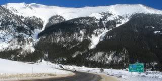
Heh...
The picture below shows the road up Fremont Pass as seen from Mt. Democrat (no laughing. Remember, the 10th of the Ten Mile Peaks in Breckenridge is Quandry Peak, and there are other interesting mountain names as well). I like the panorama - it's hard to take a bad picture of this area, believe me...I can DO it (of course. I'm awful at pics, hence borrowing others').
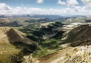
Leadville lies at 10,152 feet, which makes it the highest incorporated city in the United States (I can pretty fairly say that that includes both AK and HW). It was a silver mining town in the 19th century, then a lead and zinc mining town and, finally, a molybdenum mining town: the Climax mine is currently inactive, although it's still usable. The price of molybdenum is too low to support opening the mine. Leadville's California Gulch, which, in the 70s was full of mine tailings and dead trees, is now part of the EPA superfund. There have been major efforts to clean up the tailings and to enhance the area. (Thank goodness!!!)
Here are a couple of pictures:
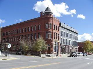
This is an historic building at the corner of E6th street. There are a lot of Victorian homes in Leadville, which was, until his death, the home of Doc Holliday (of fight at the OK corral notoriety).
Here's Leadville's town sign:

The last pass I'm talking about, over, upon? Is Guanella Pass. It is literally right behind Georgetown, CO. It's very steep and hair pinny, but you'll be going to slowly that there's no real danger going up to the summit.
Here are a couple of pictures, first of an 1890s house in , as well as Cripple Creek in / near Georgetown:
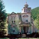

This is autumn on the pass.
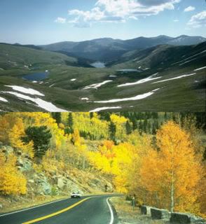
This is a spring-ish picture. It you look at the horizon, you can get a sense of just how much of a grade there is to this field.
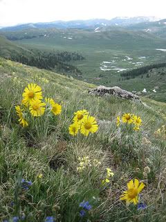
Here is the Summit Area of Guanella Pass.
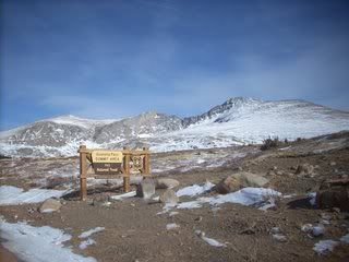
I could do tons more with passes and pictures, but I'm just giving you a flavor of what they look like. Remember, every season is different, every day is new, so you can spend ages just going through the passes and taking excellent shots to help you store memories. Towns like Leadville and Georgetown are historic and have historic homes as well as modern economies...visit them, if you ever can.
And, before we turn back to the interstate, I'm going to leave you with two signs. One is fairly common in the back country. The other one I have only seen once, and it was at the top of Guanella Pass (on the old road, I think).
Here goes!
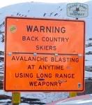

I'm very fond of the Do not Overestimate Road Width one...it says it ALL about Colorado snow!!!
George and Martha Driver - no relation to Minnie Driver or any living creature out there.
George and Martha Driver came into existence when I lived in Colorado and have followed me down the road for years. They are the folks who are driving along on Hghy 9 in late August and, above Blue River, where I lived, see a single snowflake genty dancing toward the ground from a little puffy cloud far, far above them.
Horrified, because they don't have their winter radials on, they look at each other in shock and immediately slam on the brakes and, after working their courage up, creep slowly down the (dry) road at 10 mph. Because it's snowing. Of course, they don't look behind them to see people trickling along equally slowly in their wake and wondering what the heck happened.
George and Martha, on the other hand, quickly develop their courage, to the point that it becomes er...something of a liability? Uh, yeah, that might be it...
It's January, and G and M are hauling their camper (or, better yet, driving their gargantuan motor "coach") through the Eishenhower Tunnel from East to West because they're dead set on going skiing. No matter what. George decided that he'd check his brakes a few thousand miles earlier when they'd left Texas or Florida or North Carolina, and that he didn't need to check them again. He and Martha had stopped for coffee in Georgetown and had been advised to drive cautiously down the west approach, if indeed they made it up the east approach.
George figures that 45 is a decent speed and, if he has to, he can ride the brakes to the bottom which is only a few miles away (he can see those leeeetle white dots that are houses, don't you know?)
And off he goes.
Burning brakes smell pretty ghastly. And 45 mph is way too fast for a motocoach or a truck hauling a camper down the West slope ANY time, much less January. And I'm not even pretending the snow's falling! Which it would be.
Careening wildly down the mountain, going all alone because other saner drivers have stepped waay back to keep out of his way, brakes cherry red from the heat, G manhandles his truck/motor coach as it gathers momentum.
He sees the safety ramp designed to stop semis in the same situation as he is and aims toward it (this isn't steering by this time). The safety ramp is piled feet deep in gravel that acts as a shock absorber and glue to injured wheels and brakes. George is lucky. All he has to do is appease Martha. And get the vehicle(s) he's damaged repaired. Don't worry, though, he'll be back again, not a whole lot smarter, and probably with something bigger to drive.
And what G &M do on ice is...well, sad. I stay clear of them wherever I go, dropping back 10 car lengths if that's what it takes to STAY clear of them.
Now, their great Aunt Tessie is ...er...something else. Indeed. We're in Arizona. Got yourself comfortable. We're going to be climbing the switchbacks from Oak Creek Canyon to outside of Flagstaff. So is Great Aunt Tessie, who is driving her barge...er...large sedan up to visit someone or attend an affair (or, from what I know, to HAVE an affair. Stranger (but not much stranger) things have happened.l..).
Driving behind her (immediately behind her, unfortunately) all I can see is a wide brimmed sunhat and two hands clutched around the steering wheel as if it's a lifeline. The speed limit in the canyon is about 35, but, since we're going something slow enough that a snail could jog by, I'm not worried about a speeding ticket. The road is one lane each way, by the bye. So, pretty much, where you start is where you'll end up for the trip.
I was, thank the gods, driving my metro or my Neon - I don't remember which. They both had standard transmissions, and that was what saved me from just running the barge...large sedan down.
The switchbacks (or hairpins) are, as I have said previously, very steeply inclined. Aunt Tessie, head immoblie under that blasted sun hat, begins the ascent. And sloooooowly (I'm saying the word much too quickly) we trekked toward the top. Never once did the sunhat move, never once did Aunt Tessie pick up speed enough for me to get out of second gear (or the automatics behind me to switch into drive from low, if they knew enough to find low and stay there). Climbed those hairpins one at a time, she did. Had no idea that there was a line of traffic behind her, either. All she could ssee was straight ahead and alll I could see was the hat and the hands...
At the top, there's a pull out. Aunt Tessie pulled over (I'd have been worn out, too) and the look on her face when she saw how many of us were behind her was priceless. Absolutely priceless.
As far as I'm concerned, for every Aunt T. or G and M. there are 2000 excellent drivers at least. Which is what makes Gand M or Aunt Tessie (or both) stand out so much...to my last day I will remember Aunt T. as I named her...(snicker).
Tomorrow? The Grand Canyon. Because I can.!!!!!
Subscribe to:
Posts (Atom)