
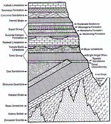
There is also a 'layer" called the Great Unconformity. What this is is a gap in the geologic record. There are several millions of years that did not leave any trace, so the rocks below on either side of it show vastly differing ages and spans. (And you think someone tearing out the last page of a story is frustrating? Imaging the geologists trying to unravel THAT mess!!!)
There are a lot of really cool horizontal layers that are pretty clear, even in the picture that I posted. You can pick out which layer something is by examining this picture and seeing pretty well where they are. Then, as the mule (or you) move down the trail, there are a series of tilted layers: this is a sign of major action inside the earth - plate tectonic actions such as subduction, that sort of thing. Whole areas of a location were raised on an angle, hence the change in direction toward the bottom of the picture.
The very bottom section shows no real pattern. The rock is big and bulky and, to be honest, very, very, VERY ancient. It's called Basement Rock sometimes. The big bruisers are there, the schists and the granites, and the age, as determined by Uranium or Potassium Argon dating is somewhere between 1.68 and 1.84 billion (yup, billion) years. . It's by travelling down through the canyon that one is able to see these ancient rocks and to somehow get a sense of the lapse of time between their foundations and now.
The Kaibab (remember that cute little squirrel?) Formation is about 270 million years ago and is at the rim of the canyon.
These are the ROCKS, not the Canyon itself.
The Canyon itself is something like 5 million years old. That's not exactly chump change, but compared to the rocks in and under it, we're not even talking the blink of an eye. Although there are varying theories, the oldest one - that the river did all of the carving on its own - is being modified to include the land uplifting around it, helping the river to do its thing, you might say. And, 5 million years ago when this all started, the river was much different than it is today...
I just wanted to show you this stuff because, to me, it's fascinating and you're either turned to another page, or you're captive (laughs a Simon LeGree laugh).
Of Mules:
Okay, I'll admit it, when I started to write about the Mule Trip down the canyon, I just sorta figured I'd describe it and that Mules were a little like Volkswagens, dependable, nothing to wild or sporty. And THEN I went looking for more information and was bowled over by what I started to learn. Soooo - tying this all in neatly with the Canyon, here is some fun stuff about mules:
Mules are the result of breeding a female horse with a male donkey. The animal that results is a hybrid and we call it a mule. ANY female horse of any breed may be cross bred. There are male donkeys of all sizes, from quite small to the biggest, which are called "Jack" donkeys and are pretty impressive specimens in their own right:
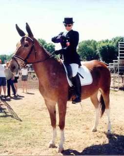
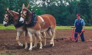
Here are some mules:
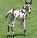

The little spotted fellow is a foal and a pretty young guy. His dam is either an appaloosa or an American spotted horse.
The lady in the second shot is preparing to enter the ring in dressage aboard her mule. Dressage for those who might not know, is an exacting discipline requiring the most explicit attention to form by both the horse and the rider or, in this case, the mule and the rider.
The third picture looks pretty much like your standard mule team. And it is, so long as one recognizes that the dam (mom) of each mule is a Belgian heavy draft horse. The dad is a Jack donkey.
In the last picture is a pair of prize winning carriage mules. Each of them stands 15.2 hands at the withers (the bump where the neck and the back meet), which is where all equines are measured. Each hand is 4 inches so each of the mules is 62 inches at the shoulder. (4x15= 60 + 2" = 62.)
Some of the characteristics of mules pretty much universally are as follows, and I'm comparing them to horses (one of my dearest loves):
A horse will eat until it founders: a mule stops when it's full
A horse will work no matter how abusive the situation, no matter how worn out the horse is, until it literally drops in its tracks: a mule will work until its life is in danger (either from hunger of exhaustion or abuse or any combination thereof) and then it stops. Which, if you get a quirky mule, may be JUUUUST a little sooner than a person might think (hence the term "stubborn as a mule"). In general, though, a mule has common sense.
A horse will run off a cliff (don't ask). A mule will stop and watch the horse run off a cliff. It will not follow it.
A horse can kick straight back or stamp an enemy under its front feet. A mule (watch out folks) can kick in any direction. So don't figure that, it you get on a mule's bad side, standing off to the side of the animal is going to help. It isn't.
But, overall, a mule has a steady and sane temperament. It's sure footed and, to my scant knowledge, no matter how irked by a screaming teenager or a sweaty businessman pretending he's John Wayne, there have been no accidents on the Bright Angel Trail Ride (a couple of pictures below):
An air shot of Grand Canyon village: the darker roofed large building with the arm that juts out toward the canyon is the El Tovar that we've already talked about. The mule corrals and stables are to the left and across the street.

These are a few of the mules that go down and up the trail. The trash bins in front can give you a general idea of their size.

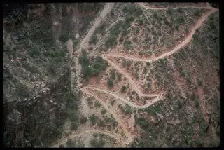
No, we haven't reached the bottom of the canyon. This is the trail as it crosses the Tonto plateau (yup, a plateau in the Canyon - who'd a thunk it? See that edge there where it looks like the trail just goes "blip" and ends? That's the next leg of the journey!

Here's the another trail from the air:
Mules have the right of way. If hikers are on the trail, they must step aside (against the wall edge).
My brother and his lovely wife Karen as well as another couple, the husband of which is an EMT, did the hike down from the North Rim (took 2 days) across the bottom of the canyon and then up the South Rim. They also trained for months to do it, and did it in the winter. It was still a run for the money. The walk is strenuous - if you feel adventurous, that's fine, but think it through. I think that the mule rides on the South Rim are booking a year out, but I could be wrong. Go to www.grandcanyon.com/gdnmule for information about booking rides from both the North and the South Rim(s).
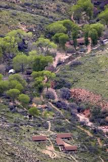
If you're riding down (or walking down, for that matter) there are a couple of places to stop: Indian Garden: this is the grand canyon version of that most important of places on any road: the rest stop. Depending on the tour you're taking or the hike you're contemplating, this is either a lunch stop before going on or the lunch stop before going back. The shot is from the air.
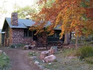
Should you be heading all the way down to the bottom of the Canyon by mule, you'll be staying overnight at the Phantom Ranch: this is just one of the cabins at the Ranch, which was originally built in 1922. The cabins are wood and stone from the canyon. This was originally a playground for the rich and famous who could afford to make the trip (a) to the Canyon itself and (b) to the bottom of the Canyon when they got to it. There is also a campground nearby.
At the bottom of the canyon, besides tremendous geology, there are the Havasu Falls:

See the rim of the Canyon WAAAAAY up there? Uh huh, that's a loooong way!
The Supai Nation also has its village in the bottom of the Canyon: I do not know the protocol for visiting the village. These are peoples' homes. If you are interested, I would suggest contacting someone at the Canyon via email. I'm sure that any questions that you might have can be answered.

There are other trails to be followed. There is a mule train that goes from the North Rim to the bottom of the Canyon and there are several other hiking trails of varying strenuousness. (Folks, remember, the Rim of the Canyon is over 7,000 feet above sea level on the South. Hiking even a gentle trail at that altitude can be difficult).
And this closes (you're cheering, I know) my tremendously long entries about the Grand Canyon. To say the least, I've only scratched at the surface. There are tons of images out there, humongous mountains of data, and, of course, the Canyon itself. I hope you've enjoyed! I've had a great time doing this!
Next? Heh..Gennessee Country Museum in Mumford New York (I needed a breather).
Have a great whatever!!!
No comments:
Post a Comment