
Actually, one can reach Flagstaff by staying on the interstate. If I'm a semi driver or have a motor 'coach' (as opposed to a camper), I'd say that Interstate is the SANE way to reach Flagstaff.
That being said, as long as I can possibly make my way up the switchbacks without losing control of my venhicle, I shall climb them.
To do that, one leaves the interstate at exit: 179. I would do that either in the morning just a bit before sunrise or in the late afternoon as the sun is preparing to dunk itself behind the hills. Those (and all day any cloudy day) are the best times to see what shows up in the windshield in front of you as you drive toward Sedona, passing through the Village of Oak Creek (I lived there for 9 months some years ago).
Here's some of what you see:
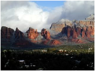
This photo was taken during the winter (yes, that's snow). It gives you an idea of what the Red Rocks are like. Here are some more shots, again, taken by much better photographers (they have not, for example, broken their cameras by simply looking into the lens) that I will ever be.
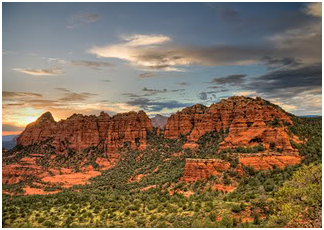
This is a sunset shot - nothing's been retouched. The rocks are incredibly colorful and vibrant. And VAST - very, very, VERY vast as in tall and huge...
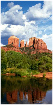
This is Red Rock Crossing. It's been in commercials for (gasp) Cigarettes, cars, you name it. It's also a great place to slide down the rocks in the creek. Whether you want to or not. The slipperiness is caused by a mossy type plant that grows underwater (I'd call it seaweed, but the nearest ocean is about 8 hours away...creek weed?). I found out that that slippery stuff is wickedly hard to walk over without ending up on your butt, bruised and sliding down the creek anyway! Yup, gotta love those deserts...sorry, I couldn't help it...
Bell Rock, which is pretty well known, lies on Government Open Range about 1/4 mile from what was my parents' back fence (they have since moved farther south). It's not an easy climb to scale it, but it can be done. Here's a picture of it:
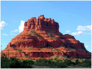
Not a bad thing to see from your kitchen window, eh? Remember, oh please, that these things are massive. As in LARGE. That's one of the drawbacks to pictures...but at least you have an idea!!!
Open Range - I forgot to explain that. It's a common phenomon in the West. All it means is that, as you putter along in your vacationmobile through vastness with few if any bob wired fences (or any other kind of fence, for that matter) remember one thing: Cattle, goats and sheep have the right of way. If you kill or injure someone's livestock, you pay for it. (As in you pay cash for it), and a steer can be one heck of a lot of money. So have a little caution lest you find yourself shelling out a grand or two for a prize Shorthorn. I learned just how good my brakes were one evening on my way home from work in Sedona. There's this really cool twisty place that dives down and does a 270 at the same time. Although ever fiber of my being was asking for me to play, something told me to be careful. And even then I almost didn't stop in time when the steer appeared, standing right in the middle of the road. And then there was that herd of goats that scrambled down the embankment at the side of the ride going North through the Navajo Reservation. They're considerably more nimble than cows. And faster, but I was lucky enough to see 'em coming and squealed to a halt just in time.
I just realized that this must seem to be pretty long (and it is). So I'm going to post this and come back for the switchbacks and Schnebly Hill Road later. Later today, that is!!!
(P.S., yup, we wander to the canyon, too, but I may head south to Tucson first...).
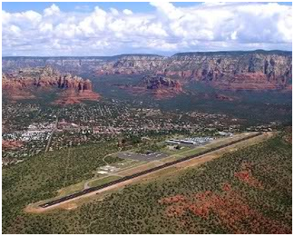
More pictures of the Red Rocks: The first is from the STOL Sedona Airport and is a panoramic view of the area from airport approach. (STOL - Short Take Off/Landing)
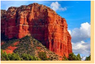
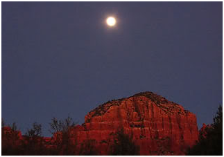
The picture on the left looks like it might be Jacks Canyon. The picture on the right is a timed exposure, for sure, and shows a full moon over the red rocks.
No comments:
Post a Comment