
Now, you have to understand that there's TONS of stuff to see between where we were and the top of the slope, but I LOVE driving this slope, so I hopped and skipped a little bit.
Here's a lovely satellite photo of Albuquerque. The hilly stuff on the right is the East approach to the city. The city is all of that squarish grid stuff just to the left of the hilly stuff. The snakey dark squiggle down the middle is the Rio Grande River - yup, the Rio Grande River of fame and cowboy legend!!!!
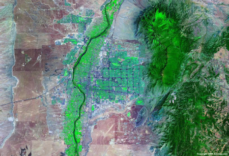
I made the picture a little bigger than usual so you could see the drop from about Sedillo (which is a dinky place on the middle right of the map almost off the edge) at 6,955 feet to Albuquerque, which is at 5,312 feet (still over a mile above sea level). The satellite image is not only one that highlights terrain: it also shows vegetation, and you can see both the light foresting and the fairly intensive farming along the river. which is fairly wide and shallow at this point.
The drop is pretty cool, but the totally neat thing about it is the fact that the road descending (or ascending, depending on where a person is going) is a series of very wide and only slightly inclined switchbacks. SOOO, if you've driven it before, you can get down without doing much braking at all. (The first rule of descending a steep, curly slope? DO NOT RIDE YOUR BRAKES! ) If I recall correctly, the speed limit for most of this is right at 55 mph, which is slower than the rest of the interstate in NM, but which will get you down all in one piece.
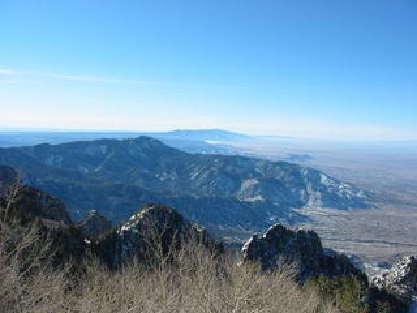
For a horizontal view, I'm including a shot looking slightly south and west from one of the Sandia Peaks. It gives you an idea of how much the terrain changes...
And, although I haven't been to one, the annual International Balloon Fiesta in Albuquerque is the direct beneficiary of the updrafts and wind conditions created by having the city embraced by the sides of the rift escarpment. I'm including a picture: the fiesta is a monster event and, as I write, the earliest you would probably be able to get a room to go to Fiesta would be for the 2010 version. Here's a picture I found of a few of the balloons involved (they come from all over the place).
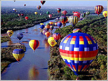
Just imagine being there! (Too many people for me, but I could probably watching the balloons floating from afar)!
Speaking of switchbacks (and we were), I'm going to do a little hop, skip and jump and wander up a ways to Oak Creek Canyon's switchbacks. But, before that, here's a shot showing the slope going west (and DOWN) just at the west portal of the Eisenhower Tunnel, I-70, Colorado. Semis going down the grade are checked before they start down to make sure their brakes are all right and their tires are good, not to mention that their loads are solid. Same thing should happen to RVs and vehicles towing ANYTHING.
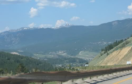
Do you see those leetle white dots at the bottom of the slope? That's Dillon, CO. See the two shiny white rectangles on the road? The one farther down is a semi (OH boy, is this road a tough one) and the one on the lower right is a smaller vehicle, or, maybe, half a modular home. Away off in the top of the picture are mountains, well, we're ON a mountain right here, but I just thought I'd draw your eye that way.
To say the least, this is summertime. Now imagine it in the winter (and understand that Colorado has some of the best road crews in the lower 48). It's "interesting", to say the least. How do I know? I lived for 4 years in Blue River, which is a small, incorporated town south of Breckenridge, which is on highway 9 south of Dillon (remember that you are looking West when you look at the mountains here.)
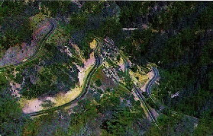
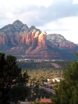
And then there are other switchbacks. These are in Oak Creek Canyon, Arizona, about which more tomorrow. Suffice it to say that the climb up the wall of the canyon is switchbacky and steep, so you're doing not only the turns, but a fairly steep climb to get from 4300 feet at the fork of Highway 89 and 89A in Sedona to 7200 feet at the top, which is part of the west rim of the canyon. I'm just showing a picture today. And a picture of the red rocks of Sedona, about which I shall wax poetic in the next instalment (well, I'll wax verbose or something).
Switchbacks, version 3: I'm keeping the picture large, and the satellite image is color enhanced. You can see the lower switchbacks pretty easily.
And here is one of the red rocks of Sedona and Oak Creek Canyon. This one is, specifically, Tea Pot Rock. I will post more in my next message. This is, arguably, one of the most beautiful places on the planet (but rock is where I'm most at home, so I am possibly biased).
AND, tomorrow, we meet George and Martha Driver (heh...).
No comments:
Post a Comment